

La Concha is the defining backdrop to the Marbella beaches and a fantastic, challenging hike. This guide covers all the information you need for hiking La Concha, plus practical tips from our experience.
The Andalusian town of Marbella is wedged between the sea and the dramatic Sierra Blanca mountains. The most striking peak in the range is La Concha. At 1,215 m high, its triangular peak dominates the end of a long ridge.
The hike to the summit is our favourite in the area and offers a wonderful break from lazy days spent on the beach.
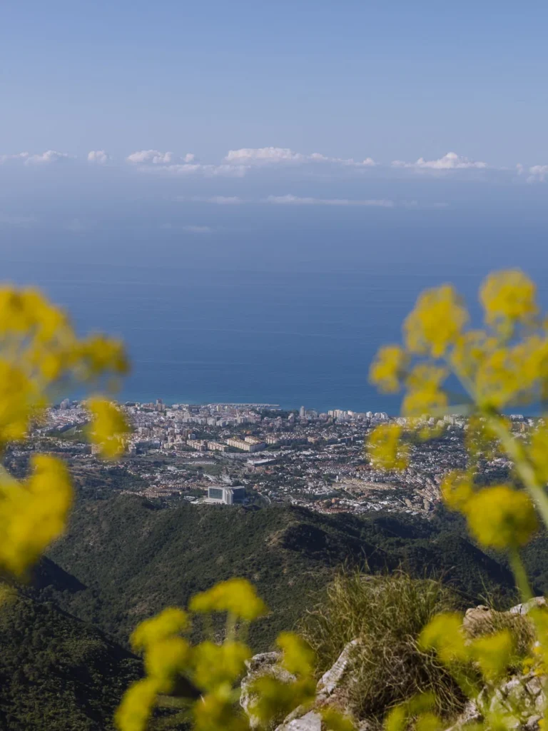
The path is interesting and varied; the views over the coast and across to Gibraltar and Morocco are excellent; and in May and June, the flowers lining the route are beautiful.
The walk, however, is not to be underestimated. It takes about 6 hours round-trip, is often rough underfoot, and the path is often indistinct.
We have done it twice, once in glorious sunshine and the other in intermittent cloud. We loved it both times, and if you are up for a challenge, it is a thrilling hike.
This post covers all you need to know to do the hike, including a map and instructions.
LA CONCHA HIKE OVERVIEW
- Start – Refugio de Juanar
- End – Pico La Concha
- Route – PR-A-168
- Distance – 6.5km one way
- Ascent – 580m
- Descent – 310m
- Return Time – 6 hours 30 minutes including breaks
- Difficulty – Medium to Challenging
The hike to the summit of La Concha is a there-and-back hike that begins at Refugio de Juanar. It follows the PR-A-168 trail. PR stands for Pequeño Recorrido, which means ‘short distance’, as opposed to GR, which stands for Gran Recorrido and means ‘long distance’.
The trail passes through a shady pine forest before climbing up a narrow track to the top of a ridge. It then winds along the ridge, traverses under a giant rock face, and finally scrambles over a narrow ridge to the summit.
It took us 3 hours and 20 minutes to ascend and 2 hours 40 minutes to descend. We stopped for 30 minutes at the summit for lunch, bringing the entire hike to 6 hours and 30 minutes.


WHAT’S IT LIKE HIKING LA CONCHA HIKE
Many people consider La Concha a small, easy mountain, but it shouldn’t be underestimated.
Firstly, the path is very rough most of the way. There are long sections where you need to step over boulders and watch your footing. After a few hours, this gets quite tiring, even though the actual elevation is not that great.
Secondly, the path is very indistinct in places and requires a lot of concentration to keep an eye out for the markers. We strayed off the path several times and found ourselves in sections that were getting a bit tricky, so we had to backtrack to find the path again.
There is also a long section where the path crosses either side of a narrow ridge. If you are not good with heights, this section might be a bit of a challenge. It’s a good reason to make sure you stay on the dedicated path.
It’s a beautiful walk and not technically challenging, but given the elevation and overall distance, it requires more effort than you would expect.
You can take several routes, but we have mapped out the easier one in the details below.


LA CONCHA HIKE MAP
Below is a map of the hike. The red line is the PR-A-168 route from Refugio de Juanar to the summit of La Concha. The numbers are a series of markers that we use to help explain the route in the hike instructions below.
The purple line is an optional detour to the Mirador del Macho Montes viewpoint and the summit of Cruz de Juanar, which we explain at the end of the post.
USING OUR MAPS. Click on the top right corner to open in the Google Maps app. Click on the star to save to your Google account.
LA CONCHA HIKE INSTRUCTIONS
START
The hike begins at the car park next to Refugio de Juanar. The Refugio is an old Parador (state-run hotel) that lies at the end of a dead-end road just north of Marbella. It’s a 25-minute drive from Marbella or a 45-minute drive from Málaga.
The last 5 kilometres of the drive are along a narrow, but well-paved road, that twists as it climbs to the Refugio. When we were last there, a few rocks littered the road, so be careful as you drive.
Parking is along the edge of a gravel/rock road on your left just before you reach the Parador. This road stretches for about 300m, and the further you drive up it, the shorter the walk. However, the further you go, the rougher the road becomes.
Parking is free, and we parked near the beginning to avoid the large ruts in the road. At weekends and on nice days, parking can fill up, so try to arrive early.

REFUGIO DE JUANAR TO PUERTO LAS ALLANAS
Time: 1 hour 10 minutes
We left the car and headed up the gravel/rocky road past the remaining parking spaces and through the side of a metal gate, which is the start of the walk.
From here, the wide track climbs gradually, under a lovely canopy of pine trees. We kept to the right following the signs La Concha, ignoring the signs to Mirador del Corzo on our left.
The pines are now replaced with beautiful flowers and eucalyptus trees lining the trail.
Twenty minutes after leaving the car, we reached a split in the trail (marker 1 on the map).
We turned right following the PR-A-168 to La Concha. (Ignoring the Mirador del Macho-Montes and Cruz de Juanar trail on the left).

The path does two sides of a triangle around an outhouse, passes a line of olive trees, and heads deep into a pine forest.
After a few minutes, we arrived at another junction of paths and turned left, following the sign to La Concha (marker 2 on the map). The sign indicates only 2 hours to the summit, but we found that a bit optimistic.
We followed the wide trail as it gently meandered through the pine forest.
Before long, the path left the shaded forest, narrowed and began to climb.
From here, the track becomes rockier and now takes a bit of effort.
The rocky track became increasingly sandy, but just over an hour after leaving the car, we reached the ridgeline at Puerto Las Allanas (marker 3 on the map).


PUERTO LAS ALLANAS TO PICO DEL LASTONAR
Time: 1 hour
We turned right at the junction of paths at Puerto Las Allanas and were pleased to see the path flatten out. Rosemary and wildflowers lined the pretty trail, and views over Marbella and the sea flickered through the trees.
After 5 minutes, the path split, and we took the left-hand fork signed to Juanar La Concha (3.3km). This easy trail steadily climbed before reaching a large cairn. Keeping right at the cairn, we immediately came to the wooden pole at Puerto Los Tres Pinos (marker 4 on the map).
We turned left at the pole and descended on a rocky path. After another sharp left turn, the path traverses under the huge rocky face of Salto del Lobo. It is a dramatic and exciting section of the walk.
The path clings to the edge of the rock, and at times, there is a steep drop on your right. There is one tricky section where a narrow ledge is only about 50cm wide, but there is a chain to hang onto while you take the two or three steps required. Neither Paul nor I like exposed heights, but we both felt fine.
At the end of the traverse, we climbed back up to the ridge (marker 5 on the map), and Pico del Lastonar appeared in front of us.
We now followed the path as it contoured to the left of the summit. The route can be indistinct, so look for small cairns or white and yellow paint marks on the rock. Before long, we reached a large cairn on a narrow-ish ridge (marker 6 on the map).


CAMINO DEL LOBO TO LA CONCHA
Time: 1 hour 10 minutes
All that remains is to hike along the narrow ridge (Camino del Lobo) to the summit of La Concha. However, the ground beneath is uneven, and the path alternates between following the top of the ridge and trails running just below the peak.
There are various route options, and finding the easiest is not easy. Keep your eyes peeled for wooden poles, cairns and yellow and white paint on the rock. Whichever route you take will involve some light scrambling, but the trail is exciting, and the views are excellent.
We have described the route we took below and tried our best to mark it on the Google Map above.

From the cairn, a rocky outcrop blocks the route along the top of the ridge. To navigate around the outcrop, you must circumnavigate it to the right. A wooden pole marked with yellow and white markings points the way.
Turn right at the pole and head slightly downhill to another wooden pole, turn left and climb back up to find yourself on the other side of the outcrop. The path now heads across rock to another sign (marker 7 on the map).
Here you have a choice – head along the top of the ridge (signed Pico La Concha) or head along a path that skirts the summit to the right. The ridge looked a bit airy and exposed, so we took the path to the right.
We turned right at the sign and went downhill to another sign, where we turned left and followed the trail below the summit ridge. Further along, the two trails meet up and pass to the left-hand side of the ridgetop, before regaining the top and heading along the apex.
Shortly before you reach the summit of La Concha, make sure you take the path off to the right. It’s much easier than the last section of the tricky ridgetop.
We reached the summit just over 3 hours after leaving the car.


LA CONCHA SUMMIT
We have completed this walk twice, once in glorious sunshine and the other in cloud. On a clear day, the views from the summit are wonderful.
To the south is Marbella and the Mediterranean Sea. To the west is Istán and the Embalse de la Concepción reservoir. To the east and north are craggy mountains and rocky facades. In the distance, the rock of Gibraltar rises out of the sea and Morocco shimmers on the horizon.
There is a wooden bench to rest your weary feet and soak in the views. We spent about 30 minutes having lunch before heading back down, which took us 2 hours and 40 minutes to trek.
The entire hike took us 6 hours and 30 minutes. At the end, we walked past the car and up to the Refugio de Juanar for a beer on their pretty outdoor terrace. It was an excellent way to celebrate a great day in the mountains.


OPTIONAL ROUTE VIA CRUZ DE JUANAR
The last time we walked up La Concha we made the route slightly more challenging by heading over Cruz de Juanar. At marker 1, instead of following the PR-A-168, follow the sign to Mirador del Macho Montes, which has views over Marbella.
From the mirador, retrace your footsteps a little and then turn left to follow the sign for Cruz de Juanar. The path almost immediately splits again, take the right fork and climb steeply up the zigzag path.
As you approach the summit, the path gets rockier and rockier and at times requires a bit of scrambling. A metal cross marks the summit, which provides wide-ranging views of the coast.
The path then drops down the other side and rejoins the PR-A-168 at Puerto las Allanas. (See purple line on map above).
The detour adds about 30 minutes and roughly another 150 metres of ascent and descent to the hike. It’s good for the extra challenge, but you don’t miss much in the way of scenery if you decide to skip it.


TIPS FOR HIKING LA CONCHA
- The ground is rocky underfoot so sturdy footwear is necessary. We did the hike in trainers, and we were fine, but hiking boots would be better.
- Try to start the walk early to get the climb up to the ridge done in the cooler morning temperatures.
- There is very little shade once you’re out of the pine forest, so make sure you’re prepared with sunblock and a hat.
- There are no facilities on the route, so bring plenty of water, snacks, and lunch.
- Take a map and instructions. You can use the one above or download maps.me, which has the trails marked.
- Take time navigating the ridge, keep an eye out for the wooden poles, cairns, and white and yellow markings on the rock.
- Treat yourself to a beer at the Refugio de Juanar at the end.

WHERE TO STAY?
The most convenient place to stay is the Hotel El Refugio de Juanar. Despite its name suggesting a mountain hut, it is, in fact, an excellent hotel with good facilities. There is nothing near it for miles, so it makes for a relaxing rural retreat.
Another excellent choice is Marbella. Just 25 minutes by car, it offers a diverse range of accommodation, a charming old town, and a host of golden beaches. You can read our review of the best Marbella beach clubs here.
Search for Marbella hotels here.


MORE ANDALUCÍA GUIDES

ANYWHERE WE ROAM IS
READER-SUPPORTED